

To be absolutely clear: Each pilot has the responsibility to be current on airspace information regarding his flight path. This responsibility cannot be delegated, but will always rest with the pilot himself.
Airspace maps:
https://secais.dfs.de/pilotservice/home.jsp#
(after free registration the German ICAO map and NOTAMs can be accessed)
Benelux: Notaminfo Benelux
ED-R activity:
Check AIP or regard them as active. Watch out for NOTAMs, not all ED-R have fixed activity times.
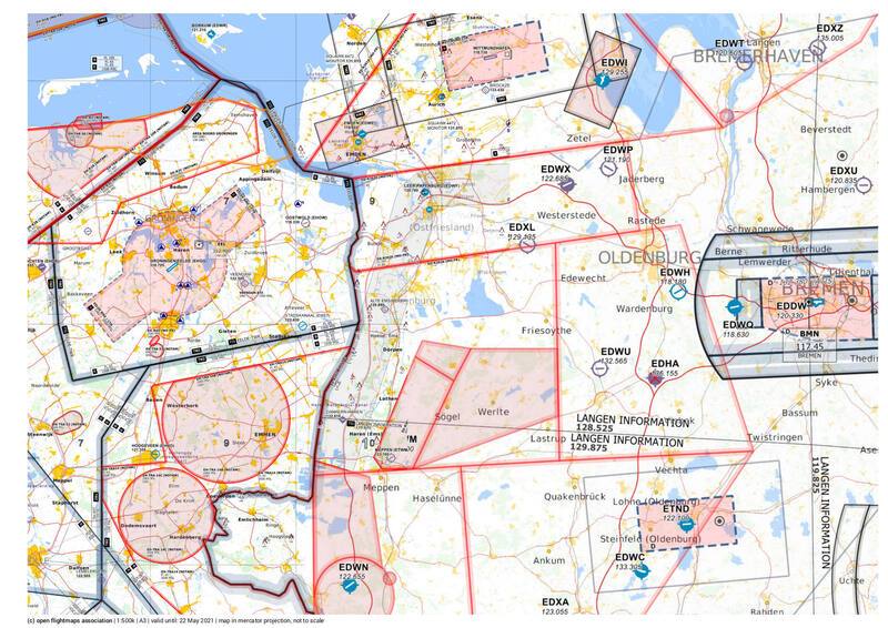
Relevant airspace near our sites:
- TMA-TMZ EELDE (118.705 MHz) near Groningen above 450/420 m (starts right at the country boarder of the Netherlands!)
- TMZ south of TMA-TMZ Eelde: Weekends from 1980 m (FL65), otherwise 1370 m (FL45)
- Check out the new Lelystad TMA-TMZ (135.180 Mhz) further into Netherlands
- after Hoogeveen airspace from 1370 m (weekend, otherwise lower), even lower after Zwolle (360 m).
- NW from Hoogeveen also 1370 m TMA-TMZ, before Emmeloord 360 m.
- between Zwolle en Almelo a weird TMA-TMZ finger with 1670 m (weekend, otherwise 1370 m).
- RMZ Emden (118.605 MHz) + Wilhelmshaven (129.255 MHz)
- New: TMZ (HX) Wittmundhafen (118.730 MHz)
- D (HX) Wittmundhafen (118.730 MHz)
- D(HX) Diepholz (122.530 MHz)
- Parachute jumpzone Westerstede (122.685 MHz)
- Airspace Bremen (120.330 MHz)
- ED-R 34 (A+B: Mon-Fri, C: activation by NOTAM)
Glossary and explanation:
- TMZ: Transponder mandatory zone (we have no transponders, possibly permission can be requested)
- RMZ: Radio mandatory zone (active communication necessary on airband)
- D (HX): Class D regulated airspace, not always active (but activation possible on short notice, requires airband radio)
- ED-R: Restricted airspace in Germany, entry strictly forbidden, activation times need to be checked (plus NOTAMS if activated by them)

")